
Water is always moving. Whether you are paddling on a tidal river, crossing an estuary, or working your way along the coast, currents are a constant presence, sometimes helpful, sometimes frustrating, and occasionally dangerous. Understanding what drives currents and how to recognize them is one of the most useful skills a sea kayaker can develop.
Types of Currents
River currents are driven by gravity, water moving from higher elevation to lower elevation. Their speed depends on several factors including the volume of water flowing, the width and depth of the channel, and the steepness of the gradient. Water accelerates through constrictions, whether the river narrows horizontally or shallows vertically, so pay attention to those spots on your chart. In a tidal river, the picture gets more complicated because the river current may be working with or against the tidal flow. After a heavy rain, or when rivers are running high, river volume can actually overpower the tides entirely, making conditions very different from what the tidal predictions might suggest.
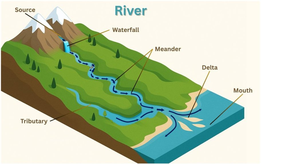
In the picture above, the water is flowing down from the mountain area into the coastal plains. The speed of the current increases around obstacles such as rocks or where the river narrows. Behind the obstacles, eddies form where the current will actually flow up river. As the river widens and the steepness of the gradient flattens, the currents will decrease. Where two rivers merge, there may be areas of turbulence as the flow from each merge. Towards the mouth of the river, the effects of tides appear. Rising tides in the ocean create a back-up of water into the lower portions of the river. As the tide goes out, the backup is released and water will flow out the mouth of the river.
Tidal currents are driven by the gravitational pull of the sun and moon on the oceans, causing the rise and fall of water levels we know as tides. As water levels rise and fall, water must move horizontally to fill and drain bays, estuaries, and tidal rivers. That movement is the tidal current. These are the currents most of us encounter when paddling on the Chesapeake Bay and its tributaries, and unlike river or wind-driven currents, tidal currents follow a predictable, repeating pattern that can be forecast in advance. In general, the flood current will flow from the ocean inland and the ebb current will flow from inland areas, bays, and estuaries, out to sea.
Where tidal flow meets an inlet or a narrow channel, the effects become more concentrated and powerful. The same volume of water is forced through a smaller opening, so it must move faster. This is the venturi effect, and it is why inlets can be some of the most challenging water we encounter. Strong ebb currents flowing out of an inlet can extend well beyond the mouth, generating near-shore ocean currents that push along the coast, create tide rips, and produce standing waves or haystacks in shallow water. What looks like open ocean from shore may in fact be a very active and dynamic current zone. (Think about the southern end of Smith Island when we are at Kiptopeke)
In addition to the tidal currents, we can also see local wind-driven currents where the flow is at or near the surface. These currents are more localized and harder to predict. There are cases where wind driven surface currents can actually have more of an effect on paddling than the predicted tidal currents. This is because the kayak is affected most by the surface waters.
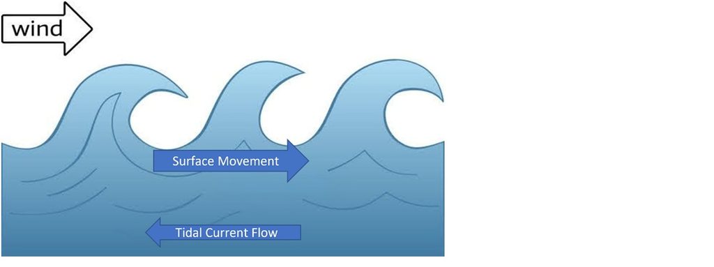
Think about what might happen if you have a swimmer who does not hold the kayak after a wet exit. The kayak is primarily on the surface of the water and can be rapidly moved by the wind while the swimmer is deeper in the water and is pulled away by the current.
Finally, there are the deep ocean currents driven by differences in water density caused by temperature and salinity differences, known as thermohaline circulation, which drives large-scale systems like the Gulf Stream. As paddlers we won’t feel the Gulf Stream on a day trip, but river currents, tidal currents, and the near-shore ocean currents they generate will absolutely shape your day on the water.
Predicting Tidal Currents
Predicting tidal currents begins with NOAA’s current prediction tables, available at https://tidesandcurrents.noaa.gov/currents_info.html then select Current Predictions. Unlike tide predictions, which tell us how high or low the water will be, current predictions tell us how fast the water is moving and in which direction. NOAA maintains a network of current stations, both harmonic stations, which use direct measurements to generate predictions, and subordinate stations, which calculate their values using offsets from nearby harmonic stations. You can browse stations by region and state, search by station name, or use the interactive map to find a station near where you plan to paddle.
When you select a station, the first thing to note is the station information block at the top of the page. This includes the station ID, and the latitude and longitude of the station in decimal degrees, not in the degrees, minutes, seconds format you may be used to from a chart. This matters because the station’s position tells you exactly where in the channel the current is being measured. Current stations are placed to serve commercial shipping, which means they are typically located in the deepest part of the main channel.
Let’s use Woods Hole Strait as an example of how to use current predictions in an area where we have data. The map below shows an overview of the area. Note that there are many islands, the Cape Cod Canal, and Cape Cod itself that will significantly impact the way currents behave.
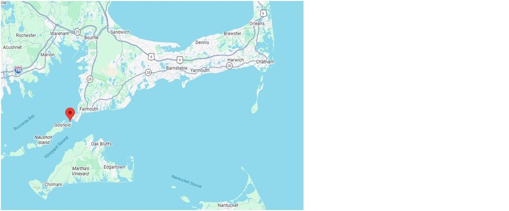
There are many ferries that pass through the strait on the way to Martha’s Vineyard and Nantucket and this means that there is a lot of commercial boat traffic and current predictions are readily available. When you get the current prediction, note the station name and location (in degrees decimal).
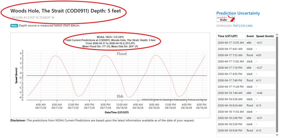
Woods Hole Strait has very strong currents due to the narrow passage between Cape Cod and the surrounding islands. Note that in the text predictions, the ebb is reflected as a negative number and the flood is a positive number. The current speed is in knots.
It is very important to look at the direction of the currents, especially in this type of area. You can plot the location of the current station on your chart and use the directions of the flow (Degrees True) to visually represent the direction of the current. In our example, you might assume that the ebb current would be flowing from Buzzards Bay into Vineyard Sound, instead it is the opposite. Making decisions based on assumptions could result in a very difficult and potentially dangerous trip.
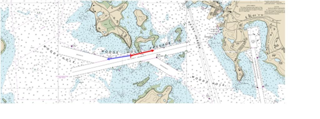
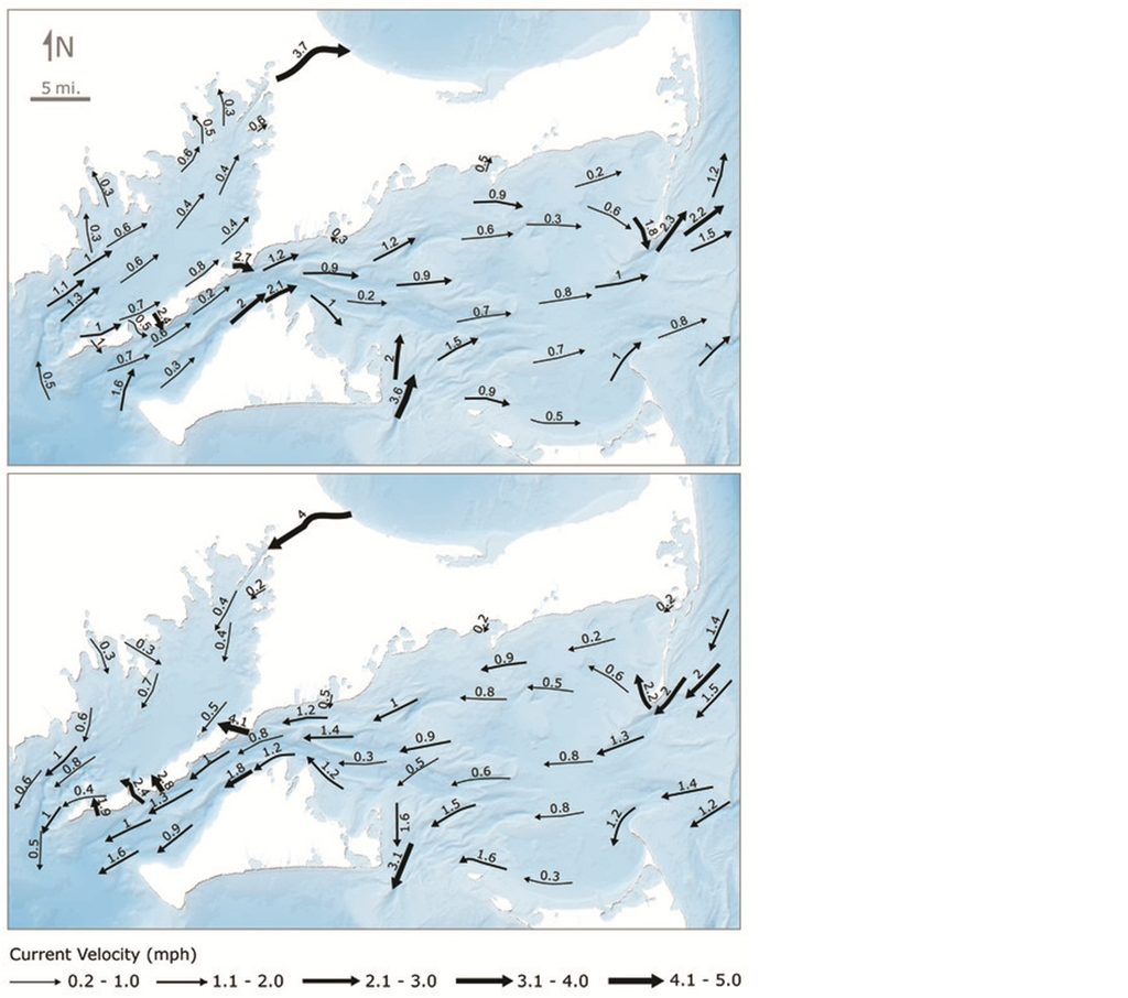
The next question is why. Understanding current flow when we have current stations and data helps us understand how currents might flow where our data is limited. Water tends to take the path of least resistance and the islands around Vineyard Sound cause restrictions to that flow. In addition, the tidal range in Vineyard sound is less than the tidal range in Buzzard’s Bay. For example, the tidal range at Uncatena Island at the western end of the straight is between 4 and 4.5 feet, while the tidal range at Falmouth Heights at the eastern end of the straight is only about 1.5 feet. The hydraulic pressure caused by these differences in water level contribute to the strength and direction of the flow.
So, looking at the big picture we see that the flood currents essentially flow into Buzzard’s Bay from south to north then west to east into Vineyard Sound and Nantucket Sound and the Ebb is generally the opposite.
Using the Current Data
Current strength is a major consideration when planning paddles. Notice that the current strength in Woods Hole strength is just above 4 knots. Most paddlers would not be able to make headway against this current. Current predictions give the speed at maximum ebb and flood, but we need to extrapolate the flow for times between. The 50/90 Rule helps us do this.
- At end of 1st hour, current will be going at 50% of max rate
- At end of 2nd hour, current will be going at 90% of max
- At end of 3rd hour, current will be going at 100% of max
- 4th hour = 90%
- 5th hour = 50%
- 6th hour = slack
This rule makes several assumptions, that may not be true. First and most important is that we do not always have a 3 hour interval between slack and max current. In these cases, you can divide the time between slack and flood into thirds to get a better estimation of the duration of each period. In our Woods Hole example there is only about 2 hours and 15 minutes between slack and max ebb. That only gives us 45 minutes for each period. To cross the strait with minimal current we would need to time it very close to the actual slack.
We can also select days when current flows might be less. Current flow varies with the spring and neap cycles based on the tidal range, the height difference between high and low tide. In a hydraulic system like Woods Hole, this range directly dictates the “pressure” forcing water through the passage.
During spring tides (New and Full Moons), the Earth, Moon, and Sun align, creating the greatest gravitational pull. Current velocities are at their peak. In the Woods Hole Strait, while average currents are around 4 knots, they can hit 7 knots during extreme spring cycles. Because there is a larger volume of water moving, there may be more turbulent water and stronger eddies.
During neap tides (Quarter Moons), the Sun and Moon are at right angles, partially canceling out each other’s gravitational pull. Current velocities are at their minimum for the month. These cycles offer the most manageable conditions for transit, with slightly longer slack water windows and less dramatic cross-currents.
Relationship between Tides and Currents
In a typical harbor, water stops moving right at high or low tide. However, in many locations there is an offset between high and low tides and slack. The reason slack water and high or low tide rarely coincide is that they measure two different things, water level (vertical) and water movement (horizontal). While they are driven by the same forces, their timing depends on how the local geography interacts with the tidal wave.
The relationship typically falls into one of three categories:
- Progressive Wave (Delayed Slack) occurs in most coastal areas and bay entrances where the tide moves like a wave traveling through the water. Water continues to flow in even after the local water level has peaked because it is still filling the bays or estuaries farther inland. The end result is that slack water often occurs 30 to 90 minutes after high or low tide. In some extreme cases, the current can keep flowing for up to three hours after the tide has turned.
- Standing Wave (Synchronized) occurs most often at the very end of a large bay or harbor where the tidal wave hits a wall and reflects back. Because the water has nowhere left to go, the horizontal movement stops at almost the exact same moment the vertical level reaches its peak. The end result is that slack water and high/low tide occur simultaneously.
- Hydraulic Current (Height-Driven) occurs when the water is not following a single wave; it is being “pushed” from whichever side is currently higher. Maximum current occurs when the height difference between the two ends is greatest. Slack only occurs when the water levels at both ends are equal. These occur in areas where different bodies of water are connected by relatively narrow passages. Restricted or narrow passages between islands can also create hydraulic effects on local currents as well as canals such as Cape Cod Canal and the Chesapeake and Delaware Canal.
External factors can also cause changes in the timing of slack relative to high or low tides. These other forces can advance or delay slack water:
- Momentum & Inertia: Huge volumes of moving water have significant mass. Even after the tidal force reverses, it takes time for friction and gravity to stop the physical movement of the water.
- Outflow from high river runoff (from rain or snowmelt) adds extra outward pressure, which can significantly delay a flood slack and speed up an ebb slack. We often see this happening in the spring in San Francisco Bay.
Strong, sustained winds can pile up water at one end of a channel, shifting the time of slack water by 30 minutes or more. This frequently occurs at entrances to inlets such as Matanzas Inlet in Florida. East winds back up water in the inlet until enough pressure from inland waters can overcome wind effects. Once this happens currents rapidly build up speed.
Share This